With under a week until we hit the trail, we are scrambling to tie up all of the loose ends. We have made a last minute change to the plans. We have decided to head up to the Canadian border to attempt the trip southbound, instead of northbound.
At the Outdoor Retailer show about a year ago I met, a friend who had previously worked for Big Agnes. He had moved on to working with Sweetwood Jerky. We were at a party after the show and nobody had eaten. My friend was circulating some sample bags of various flavors of jerky. They were delicious! Other hikers were at the event and we were fighting over the bag. Later that night I met some of my friend’s co-workers and lined up to get some samples for upcoming trips.
After eating this jerky for the better part of the summer on multiple hikes, I highly recommend it. It is much better than any other jerky I have ever had and makes gas station jerky seem like something else altogether.
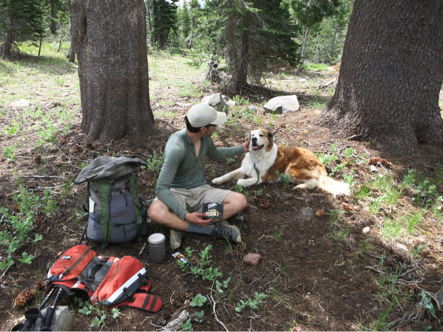
Yoni wanted some jerky, but there was no way I was giving any up. She had to settle for some petting instead.
Sweetwood is headquartered in Steamboat Springs, CO. All of their cattle are grass fed and antibiotic and hormone free. You can taste the difference.
The jerky comes in Original, Teriyaki, Peppered, and Hot flavors and they have new meat sticks called Fatty, sold in Original and Jalapeno flavors. I have not yet tried the new Fattys but I can’t wait to get my hands on them! My only gripe is that each bag should have more than 2 ounces of jerky since it is so good and is hard to stop eating!
Disclosure: I received some free boxes to try out on some of my hikes.
Ever since I first stepped foot on the PCT I have been thinking about this trip. For years I have been calculating and coordinating various aspects and weighing the challenges, equipment, and possibilities. It’s been on my to-do list for a while now, or maybe I should say to-try list. More so then ever, this will be a highly variable trip. One that we will need to be flexible and accommodating, and often our schedule will take the backseat to Mother Nature’s. It will be a challenge and I know it’s not always going to be fun, but oddly enough that is part of the fun.
The plan is to try to thru-hike the Pacific Crest Trail this winter. By thru-hike, I mean use whatever human powered means of travel is best for the conditions. This will range between, hiking, snowshoeing, and backcountry skiing, and staying along the PCT corridor. We are calling it the PCT corridor because due to conditions and snow cover it will be virtually impossible to stay on the trail at all times. Often the trail tread will be buried under 15 feet of snow.
Pepper and I will be heading out from Campo, CA at the Mexico/U.S. border on October 21st. We will be heading in to the heart of the winter as we move north. Planning and logistics get interesting for the trip too. Some of the factors that we have had to think through are seasonal road closures and resupply options, lightweight gear options for 4‑season use, and potential avalanche safety and conditions. It has been an interesting challenge. We both have a decent amount of winter travel experience and this should help a lot although we have still factored in nearly 30 zero days to give us some flexibility to wait out conditions or storms. We’ll likely have to carry at least one extra day of food at all times once the winter sets in. We are factoring an average daily mileage of around 15 miles per day, well below our typically on trail daily mileage, and if all goes well we expect the trip to take somewhere around 5 months. Lastly, we will be taking pika data for Adventurers and Scientists for Conservation again along the way.
Some reasons this trip has appealed to me for a number of years:
Hardly anybody will be in the backcountry and seeing familiar places at a different time of year.
This type of trip adds additional physical, mental, and logistics challenges to a normal three-season thru-hike. It is the progression of challenges and building of skills that I enjoy.
I hope to extend the view of “the hiking season”. Overall my winter thru-hike of the AT was very enjoyable and an amazing experience. It is so different from summer on the AT, but is not crowded and still largely accessible for a wide variety of people.
It will be interesting to incorporate our typical ultralight mindset to all of the equipment and systems that we will be using throughout the trip.
Some reasons this trip will be challenging:
It will be very hard to make solid and consistent progress during the winter, especially in fresh snowfall.
Winter storms can leave feet of fresh snow in the Sierras and Cascades.
It will be hard to motivate and get up and get out of the sleeping bag and pack up in the cold weather every morning.
Some of the roads and towns or resorts are closed seasonally and create some logistics challenges that are not present in the summer.
Some of the equipment that we will be using, like skis and alpine touring set ups, are not typically used for this style and duration of travel and therefore we do not know how they are going to hold up over time.
That’s the background for the upcoming adventure………..so here goes nothing!
Check back and I’ll update with photos and more information on the trip, as well as the gear we will be using and our thoughts and rationale on various logistic challenges that we’ll face throughout the trip.
I saw a couple other products that also seemed really interesting for the UL backpacking community.
Vargo Outdoors was showing a prototype Ti crampon that was for running/light uses that could take the place of micro-spike type products. These wouldn’t be for super technical terrain but could be great for a backpacker. They were mainly for under the front of the foot and were super packable.
Vargo was also showing some apparel that had Ti infused fabric for anti-microbial. While I don’t think I would change from using merino wool since this is still using synthetic fabric, I do think this technology could be more sustainable than the current situation of using silver as an anti-microbial.
As of July 31, 2014 the Ursack S29 AllWhite has been placed on the Interagency Grizzly Bear Committee (IGBC) list for certified bear resistant containers. It is important to note that no previous models of Ursacks have been added to the list.
In 2012, Yosemite and SEKI (Sequoia/Kings Canyon National Park) turned over the Ursack testing to the IGBC. Now that the Ursack has cleared this hurdle with the IGBC, it is possible — and although I am hesitant to say it after so many years of review, maybe even likely — that the National Park Service (NPS) will approve of their use.
In light of this new approval, the NPS has not yet formally administered an approval of the Ursack S29 AllWhite. Since the review was done by the IGBC this will most likely have to be approved but he NPS before permitting hikers to carry the Ursack instead of a hard-sided canister. I WOULDN’T push your luck carrying the Ursack over a hard-sided canister until the dust has settled and details have been worked out, although technically if you carry the current IGBC approval list you MAY be able to talk a ranger out of the citation.
I do not like to blow things out of proportion like the typical mainstream media, but this has not been heavily publicized and needs to be said.
I firmly believe that there is an epidemic on the Appalachian Trail. I haven’t thru-hiked the Appalachian Trail since the winter of 2005/2006. However as an active member in the long distance hiking community, I receive reports from various sources and feel it is my responsibility to write this post.
I would estimate that at least 30% of the thru-hikers on the AT, and probably more than 40%, are contracting Lyme Disease – many undiagnosed. The AT passes through grassy fields and woodlands while traversing prime Lyme territory. I remember days, where I pulled hundreds of ticks off Yoni. Since there were so many, they would crawl back on to her while I was pulling them off. I started dropping them into my fuel bottle so I wouldn’t have to pull them off twice. There was a sick, masochistic feeling. After an hour my denatured alcohol bottle was so thick with ticks that it looked almost like clear bubble tea. Each evening I would pour some out into my tuna can stove when I cooked dinner and get some extra satisfaction.
Lyme is scary for many reasons. The first is that many of the symptoms can be commonly mistaken for general hiker/thru-hiker maladies – joint pain, muscle aches, headaches, stiff neck, and fatigue. Who hasn’t been tired one day, had muscle aches, joint pain, or a headache on a hot day or dry stretch? (The infamous and telltale bulls-eye rash does not always occur – and if it does you are one of the lucky ones since it is easier and quicker to diagnose). Many deer ticks, especially the nymphs, can be much smaller than a sesame seed.
It’s also a tricky little bugger and commonly gets false negatives in the CDC approved blood test. Currently the CDC evaluates medical studies every 5 years. They are oddly disconnected from the beliefs of many Lyme Literate Medical Doctors (LLMDs).
Most LLMDs believe that Lyme can sit dormant if not treated immediately. The bacteria can “hide” from your immune system and come out at a later time when your immune system is weakened. This can make it very difficult to diagnose and treat. The CDC does not currently believe that there is anything considered “Chronic Lyme” or “Long Standing Lyme”. I have had multiple friends that I met on the AT get diagnosed years after their thru-hikes.
Furthermore, many LLMDs also acknowledge that Lyme is often accompanied by a co-infection. If you catch it early these are both treated together with antibiotics. If yopu wait these can be much harder to treat. Some common co-infections include ehrlichiosis and babesiosis. The Igenix blood test will also test for some co-infections, unlike the common Lyme blood test approved by the CDC.
Keep in mind that many doctors in your area might not be aware of Lyme. It could be up to you to self-diagnose and let your doctor know that you have hiked the AT or in a Lyme prevalent area. The range is currently spreading, with the Midwest being the fastest growing region, but Lyme has been reported in much of the country and even Europe and South America. Statistics could be skewed because of false reporting or misdiagnosis. I live in California and many doctors would not even think of Lyme Disease for a diagnosis, even though there have been reported cases in the foothills of the Sierras, Coastal Range, and other areas.
None of the recommendations below are fool proof but I recommend taking proper precautions and being extra careful:
Wear light colored clothing to make it easier to spot ticks crawling on you.
Do daily body checks. If you are thru-hiking, get in the routine of doing body checks every evening/night before you go to sleep and quick scans at breaks. Make sure to check warm areas, like arm pits, head, behind your knees, and groin. Often you can find ticks crawling on you before they bite you. If they have bitten you and you get the tick off before 24 hours, then you have little to no chance of contracting Lyme. After 24 hours your chance increases. If the tick has been in you for three or more days, you probably contracted Lyme — if the tick has it. For reference, in Southern NY near where the AT passes through, 25% of the deer ticks currently spread Lyme.
If you develop a bulls-eye or are worried about a tick bit, go to a doctor as soon as possible. Pull the tick out and save it if you can.
Keep the symptoms in mind and if fatigue, muscle aches, or joint pain are at all abnormal or longer lasting than usual don’t hesitate to visit a doctor.
This may seem a little far-fetched since it can cost upwards of $350–500, but I would consider factoring this into your budget. If I ever hike the AT again I will probably get the Lyme blood test immediately upon completion of the AT.
If you are hiking with a dog, I would recommend preventative measures. There is a dog Lyme vaccine and Frontline type products work great. I wish they had these for people!
Tip: When you are pulling the tick out try to get it as close to the head as possible. The infections, like Lyme, are usually stored in the ticks body. After the tick bites you the fluids start to move from the body to the head. That’s why you typically have 24 hours to remove the tick before it would spread an infection to you. If you can get the entire tick out that is good, but if you rip the head off at least you have killed the tick and stopped the transfer of bacteria toward its head — if it is a fresh bite.
I won’t go into anything that they have mentioned, but I feel that there are a few things that should be highlighted that have been glossed over about the show and some of the new gear being debuted.
Icebreaker Debuts MerinoLOFT: This seems like a groundbreaking step for a lot of reasons. Smartwool was also showing some insulation layers at the show. They were all very stylish and lifestyle oriented instead of meeting my ultralight backpacking needs. However that is completely ok with me because for everyday use I don’t need to shave ounces. I think this could translate to even more innovation down the road. Wool has incredible odor reducing and “warm when wet” properties, which could take the best of both down and synthetic insulation and bring them together.
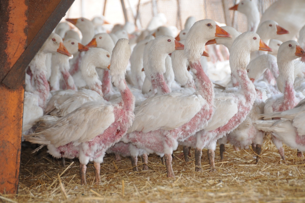
Down is the byproduct of the duck and goose meat industry. There are currently heavy price increases on down because of a shortage due to the bird flu epidemics in Asia, increased demand, and decreased farming of ducks and geese. Hopefully this doesn’t lead to more “live plucking” at down farms. Most people consider this practice inhumane.
Geese after live plucking. Photo courtesy of PETA.
I am excited for the MerinoLOFT technology used at Icebreaker because it is renewable, sustainable, and biodegradable. They take the merino wool scraps, those that would be thrown out because they pill off when they make the yarns, and process those into a merino insulation. Wool is sheared annually and is a renewable and sustainable material, and by using by products of the process make this even more environmentally friendly. I look forward to seeing where this technology goes moving forward.
Note: I have not used any of these products yet, so I am unaware of the R value of the insulation.
TurboPup:
This new “bar” for dogs has a lot of potential. I brought home a few samples from the show and Yoni loves them! They are made from real ingredients and are very healthy (I even tried one when I was hungry at the show). Ultralight hikers are always looking for a way to pare ounces. This bar has the potential to shave POUNDS! As we know weight savings leads to efficiency, decreased energy output, and the ability to go farther and be more agile. Since your dog can’t talk back to you when it is tired, the comfort of knowing your dog is doing well and ready to keep going is priceless. I did the math and for Yoni’s size TurboPup recommends 3 bars per day. I would give her 4 so she would have the extra calories on trail. Yoni eats nearly 2.5 pounds of Puppy Chow per day on the trail. Simply put, if Yoni ate TurboPup only every day she could save a stunning 50% of her pack weight! Instead of 8.8 pounds of dog food for 4 days, she would only need between 4–5 pounds of food (16 bars at 4.5 ounces per bar). Now if I could only cut my food weight in half and still be carrying enough calories!
The downfall is that they are more expensive than bagged dog food. That being said I would highly recommend TurboPup for any dog that is getting used to carrying a pack, on a long stretch without resupply, or any owner that wants to make sure that their dog is not overburdened. Remember your dog will enjoy the trail a lot more carrying less weight, just like you do!
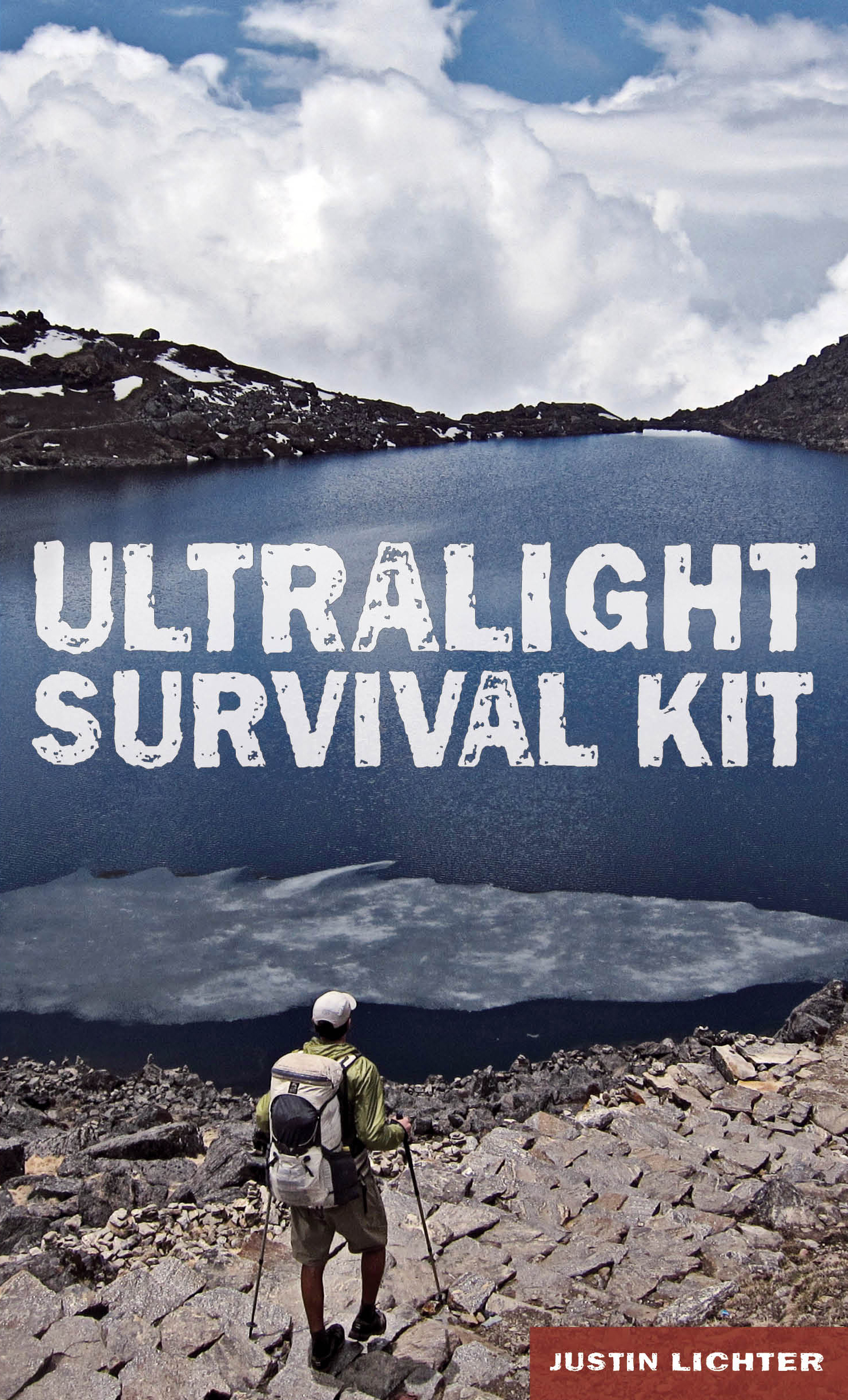
My second book has been released and is now shipping! I am excited to get this information out and to help people experience the outdoors safely and efficiently.
Cam and I completed the traverse of the Copper Canyon region on December 12, 2013. At roughly 10:30 AM on the 12th we gained the rim of Sinforosa Canyon at the Cumbres de Sinforosa (Summit of Sinforosa) near the town of Guachochi. We followed good trail on this final stretch, probably the best of the entire trip, and completed our final canyon in the traverse of the region linking all of the major canyons in the canyon system. We followed the Candamena, Oteros, Tarecura, Urique, Batopilas, and Sinforosa Canyons, as well as some side canyons, leading us in a not-so-straight line from the northwestern corner of the region to the southeastern edge. Many of the canyons along the route were over 5,000 feet deep, and some as much as 6,000 feet deep. Needless to say, the terrain was dramatic and the scenery was great.
Here are a few highlights from the various segments along the hike.
Basaseachi Falls to Creel:
The location of the start of the hike was amazing. It set the tone for the entire trip. A powerful and beautiful waterfall, with a bit of unknown. How do we get to the bottom? Which trail leads where? The bridge over the creek at the top of the falls had washed out during the rainy season prior to our arrival. Sections were dangling and leading to nowhere. What could have been easy and thoughtless turned into an adventure within the first hour of the hike. There is a natural bridge over the river just before it plunges over the precipice, but the bridge was narrow and the rock looked slick. A fall would undoubtedly mean death. We were forced to ford the river immediately upstream from the waterfall. This set the stage for the next couple of days down Candamena Canyon. It was scrambly fun, which translates in hiker lingo to “you better pay attention at all times and often tediously slow”. On day 2, we only made about 7 miles of progress while hiking for over 10 hours. In the mid morning of day 3, we hit an unexpected dirt road being built due to resumed mining operations. We followed this for a few kilometers before it petered out and then the canyon opened up a bit and we could see another dirt road leading in our direction. A few hours later we hit that and were able to stretch out our stride and get in some miles on the 6000 foot climb out of Candamena Canyon. In a contrast to the previous days in the canyon, the following day we followed a dirt road, putting in about 35 miles in 11 hours of daylight to the town of Uruachi. We knew nothing about the town ahead of time, but it turned out to be one of the most pleasant surprises of the entire trip. The town was clean and nice, with the charm of an old Mexican pueblo. It reminded me of the setting of a scene at Universal Studios where they showcase a Mexican style town. Everybody was super friendly. The shopkeeper even called the president of the village to come to meet us (which happened right after a guy in plain street clothes walked into the store with an AK assault rifle over his shoulder and told the shopkeeper to put the Coke and other things he bought “on his tab”). Heading out of Uruachi we plunged into the Oteros Canyon, which was easier going than the Candamena. We were able to make good time from there to Creel on a mix of canyon bottom travel, and trail and dirt roads leading out of the canyon and onto the rim. The terrain change was amazing on the rim. Frosts coated the meadows in the morning and pine forests lined the rim. Just a day earlier at the bottom of the canyon the temperature was in the 70’s during the daytime and 50’s at night and once out of the bottom where the water flowed the landscape was filled with desert cactus and shrubs.
Creel to El Divisadero:
We purposely planned our route to go through our hub, Creel, so we would be able to resupply easily and get any spare gear that we would need from our duffel bags stored at the hotel. We walked into Creel in the dark at around 7PM after a long day of well over 30 miles. We promptly had a double dinner and walked out of town the next afternoon. A few hours into the walk a junkie that would not leave us alone kept following us. He was chewing on a green soda bottle and had green plastic all over his lips. I am still not sure what drug(s) he was on but Cam finally had to give him a swift kick in the rear to get him to leave us alone. We hiked on and made good time as we dropped into the Tararecua Canyon passing a developed hot springs and a few cascades and waterfalls. The next day we passed a couple more hot springs that were less and less developed as we progressed down canyon. Naturally we had to stop at each one. At the last hot spring a Raramuri walked by as we were leaving. The speed of travel quickly slowed to a crawl as the canyon tightened up and boulders choked the bottom of the canyon. We luckily found one 10’ x 10’ semi-flat sandy area to camp on. The next day about an hour before dark we emerged at the confluence with the Urique River. This is a stunning area, but we soon realized the fords of the Urique would be very difficult with the high water this season. We forded the river 3 to 5 times, some chest deep and some a controlled (or semi-controlled) swim. The trail that was on the map that headed to El Divisadero (our resupply point) was pretty much nonexistent. We followed as best we could and made our way to the rim through dense plants, cactus, and everything prickly. This bit along the Urique River and the 6000 vertical foot climb up the canyon yielded remarkable views and had spectacular scenery. The day was an emotional rollercoaster with tough fords and slow going while trying to push to get to town, but was one of the highlights for me.
El Divisadero to Urique:
We hiked through a few nice rural villages and made our way through meadows and pine forests along the rim of the Urique Canyon. It was a very pretty section in contrast to the canyon bottoms that we had previously been following. We found a faint goat trail that took us to the top of the ridge right before we began our drop from the rim into the canyon bottom and to the town of Urique nearly 6000 feet below us. The goat trail faded as we passed through an old cornfield and were left standing on top of a steep, cliffy 3,000-foot drop with nothing to follow. We scoped things out and began the bushwhacking descent with only about an hour and half until dark. Luckily a few hundred yards down we came across a cattle trail that cut across our route. We decided to head left and shortly came to wood lying across the cattle trail in order to stop the cattle from going that direction (which could be a good sign since the people would not want the cattle to wander…..or a bad sign meaning that they would not want the cattle to wander over a cliff). We took it as a good sign and followed the cattle trail. Soon the trail got better and shortly after that it got even better. As we made our way down this slope we kept looking back in amazement. There was only one way down and we definitely would not have picked that way had we not found the trail! We got down the slope and hit a dirt road around dark. We walked a few hours into the night and arrived at the town of Urique for a late dinner and a toast (I had chocolate milk and Cam had a Tecate).
Urique to Batopilas:
This section, of about a day and half (45 miles or so), was supposed to be the main trail in the region and on the most popular tourist hike of the entire trip. However in the past ten years things have changed and the number of hikers has diminished from 600 a year to just a handful. The second half of the hike had been replaced by a dirt road and the trek had subsequently decreased in popularity. I have seen this countless times, including on the Annapurna Trek in Nepal. It’s a mixed bag; it can really hurt the local economy, but also can make things easier for locals.
Anyway, there are three things that stand out for this short stretch. The first occurred just a few miles outside of the town of Urique. We had already been asked if we wanted to buy marijuana a few times, once even by a man doing road construction in a huge front loader. As we were getting ready to cross the river and head off the dirt road, a man in his twenties or early thirties came over to us and tried to start passing handfuls of marijuana to us. He kept reaching into a shopping bag that was full of pot and trying to pass them to us as he smiled and laughed. We politely refused, but that was definitely a lot of pot and he was not trying to hide it at all.
In another few hours of walking up a really good trail we met a really nice Mexican guy named Prosperino. He lived in an idyllic oasis setting with banana trees, grapefruits, oranges, tangerines, and avocadoes. He even gave us a few tangerines for the road!
The last and probably most memorable thing from this section was the rain. Here we are in one of the driest regions in North America and they had already had a record breaking rainy season that ended a month prior. All the rivers were already running very high. A few hours after dark it starts pissing rain and kept up all night. We were camped on the rim and it was windy and cold. We stalled in the morning for about 30 minutes thinking that the rain couldn’t keep up much longer. Well we were wrong, it rained all day and all that night. Luckily we dropped 5000 feet through the day and the rain went from cold, windy, and freezing to warm and tropical. We walked into Batopilas an hour before dark and could dry out. The rivers were muddy and running huge. There would be no way we could ford them for a few days until things settled down. When we arrived in Batopilas the power was out to the entire town. Phone service had already been out for a couple of months since the monsoon season. At least we had a roof over our heads and a dry area to sleep.
Batopilas to Guachochi:
It was scheduled to be a couple of days until we dropped into the Sinforosa Canyon. When we dropped back in at El Realito we realized the river was still running huge and that we needed to get above a confluence of a large tributary that was about 10 miles upstream before we might be able to ford the river. We adapted on the fly and asked the locals to get their input. One of the locals invited us in. Along with the local’s insight he gave us, he also put some coffee on the table and his wife brought us over some fresh, homemade tamales while we stewed over our plans. We decided to ascend a side canyon and gain the rim and then drop back down the next day. In the side canyon we passed a couple of areas that seemed to be drug fields. This was just the beginning of what we would see over the last few days of the trip. Other than that, the side canyon and the climb out were remarkable and a true highlight of the trip.
The next day along a road walk, we spotted marijuana strewn all over the side of the road on a curve. Over the first half of the trip we had hardly seen any signs of the drug trade, but now things were starting to come to the surface. When we dropped into the Sinforosa Canyon along one of the side canyons we passed a few young men hiking out with backpacks, presumably transporting their “crops”. A few hours later we began crossing through various agriculture fields located on steep hillsides. The main harvest had occurred in the previous month and the farmers were beginning to water and plant the next crop. I quickly recognized some of the “volunteers” sprouting up in the fields. I was mainly expecting cannabis and was surprised at what they were growing. I presume that with many States in the U.S. legalizing pot that it has lost some value to the drug cartels. They were growing poppies. Upon entering any of the fields we would start yelling out “Hola, Buenos dias” repeatedly. The last thing we wanted to do was come up on anyone and surprise him. At the bottom of the canyon we crossed a few fields over the next day that were two kilometers long and had sprinkler heads rotating around. We ran through and dodged the sprinkler heads, not at all like little kids screaming and giggling in the yard in the summer. Needless to say, the southern part of the Copper Canyon region, including Sinforosa Canyon and Guachochi, seem like the epicenter of the drug trade in the area. It is a shame because this is also one of the most amazing and scenic canyons. The walls are red and rugged. It is steep and deep and remote. Travel is a bit faster than the Candamena and the Tararecua. Basically everything a hiker, naturalist, and conservationist would want……..except the added risk of the drug trade.
All in all, the hike went really well. Adaptability and getting on the ground beta from the locals was an ongoing key to the trip. Everybody was friendly and helpful, even many of the drug farmers. At one point we were a bit misplaced and cliffed out since the trails that were going to the drug fields were better than the point-to-point trails. The farmer was super friendly and excited to see us. He chatted with us and gave us directions. Very unexpected since it could have been a bad situation, but I guess the farmers are just doing there job and trying to make a living. Our timing was good too because they had already harvested and the plants that were in the ground were just seedlings. We could play dumb and we didn’t mention that I was from the U.S. I morphed back into part of my ancestry as a German and with Cam being from Australia we became neutral, like the Swiss, in the drug cartel’s eyes. Well, that was our hope anyway.
Links to pictures and a couple of videos from the trip are below and if you would like any information on the hike or the region just let me know. I have digital maps and intend to plot our route on the maps and write up info and logistics on the hike in case anybody wants to head down and do something similar.
I am flying out for Mexico tomorrow and will be meeting Cam in Chihuahua. We will then be taking a bus to Creel and then to the start of the walk. If all goes according to plan we will most likely start hiking on Monday afternoon.
You can follow along. Locations will begin being displayed once we start the trip and as we are able to post, barring deep canyons blocking satellite signal.